
Key Takeaways
- What is photogrammetry? A technique to get measurements and 3D models from photos.
- How does photogrammetry work? It uses overlapping photos and software to triangulate points and create surfaces.
- What are the types of photogrammetry? Aerial (from aircraft or drone) and terrestrial (from ground camera).
- What are the uses of photogrammetry? It is used for mapping, engineering, forensics, entertainment and more.
Photogrammetry is an important method for obtaining measurements and generating 3D models used across a wide variety of industries, ranging from engineering to sports. It’s also an affordable 3D scanning technique that’s suitable for scanning both small objects and large buildings. But what exactly is photogrammetry, how does it work, and how is photogrammetry used?
In this comprehensive guide, we cover everything you need to know about photogrammetry in 2023.
What is Photogrammetry?
The official photogrammetry definition is “the use of photography in surveying and mapping to ascertain measurements between objects”. Put simply, it’s the science of obtaining measurements from photographs.
Digital photogrammetry originated in 1984 when Ian Dowman proposed it as a way to map the topography or terrain using satellite imagery. However, the origins of its theory can be traced all the way back to Leonardo da Vinci, who in 1480 wrote on how perspective should be incorporated into illustrations by making vanishing points appear smaller and the objects that form out of them larger, as these objects are meant to be closer to the viewer’s eye.
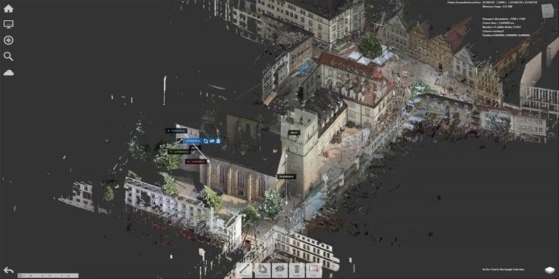
Photogrammetry works by taking a series of photos of an object, structure or landscape from different points or angles. While past decades have seen various methods used to process the images, today photogrammeters process images in photogrammetry software. This software, on either desktop software or a photogrammetry app, calculates measurements and create 3D renderings using the images.
- We also have a separate article ranking the best photogrammetry software.
For example, if you’re a surveyor wanting to chart a landscape, you can mount a camera on an aircraft flying above the landscape and take a photo every few meters. You can then input these photos into a photogrammetry software, which triangulates all photographed points to create an accurate 2D or 3D map of the landscape and generates the distance between points to scale.
Photogrammetry is a technique that’s accessible to beginners, students and hobbyists as well as professionals, due to the presence of high quality free photogrammetry software programs like Meshroom. Photogrammetry can also be used for the cheap 3D scanning of small objects, and even people’s faces.
- We also have a ranking of the best 3D scanners.
- We also have a ranking of the best 3D cameras.
The Photogrammetry Process
So just how does photogrammetry actually work? Well, the first step is to take a series of overlapping photos. With aerial photogrammetry, this is done by a camera taking a series of pictures as it flies along a flight path attached to an aircraft or drone. With terrestrial photogrammetry, this is done by taking photos of an object from a variety of different angles.
Photogrammetry works by using 3D geometry. Every point in your captured image defines a light ray in a 3D space that begins with the camera and extends out to the real point. Photogrammetry software uses the point identified between two or more photos as well as information from the photograph, such as the position and angles of the camera and the camera’s focal length, lens distortion and pixel size.

With this information, your software locates the geometric intersection of the light rays, identifying where the point is located in 3D space. Point matching is the term used to describe finding two or more points on the photos that correspond in the same 3D location, and this can be done manually or automatically. The light rays meeting up is called ray intersection, while the method of using numerous photos for solving points is triangulation.
Ultimately, photogrammetry software uses algorithms to decipher information like camera angles, locations and characteristics from just a few point matches. The software then creates surfaces, lines, texture-maps and full 3D models using the 3D point locations.
Types of Photogrammetry
There are two main types of photogrammetry – aerial and terrestrial. Let’s take a look at each type and how they work.
Aerial Photogrammetry
As the name suggests, in aerial photogrammetry the camera is mounted on an aircraft or drone and is typically pointed vertically towards the ground. Drones are used nowadays, but in the past fixed-wing manned craft and unmanned aerial vehicles (UAVs) were used. Due to the prevalence of drones in carrying out aerial photogrammetry, it is sometimes simply referred to as drone photogrammetry.

Multiple overlapping photos are taken as the aircraft or drone flies along a flight path. In the past these photos were processed in stereo-plotters – instruments that allow users to see two photos at once in a stereo view – but now they are usually processed using photogrammetry software.
Terrestrial Photogrammetry
Terrestrial photogrammetry, also known as close-range photogrammetry, uses a tripod-mounted or handled photogrammetry camera located on the ground. This type of photogrammetry is usually non-topographic, meaning it’s used to create drawings, 3D models, measurements and point clouds rather than topographic products like terrain models or maps.

Terrestrial photogrammetry can be carried out using an everyday camera, such as the one on your smartphone. It can be used for modeling and measurements across a wide range of industries, including architecture, engineering, forensics, mining, archaeology, entertainment and many more.
As well as being used by professionals, terrestrial photogrammetry is a popular technique among hobbyists. It can be used to scan general objects, people’s faces, and small things around the house, workshop or business, using just a smartphone camera and free photogrammetry software as a 3D scanning app.
Advantages of Photogrammetry
You now have an understanding of the basics of photogrammetry, but what exactly are the benefits that make it a valuable tool across such a wide range of industries?
Here are the main advantages of photogrammetry:
Accurate records – Photogrammetry can produce an actual, permanent photographic record of a particular location or object when capturing an image. As the image has metric properties, it is also a highly accurate, measured record that can be relied on for a variety of projects.
Ease, speed and affordability – it is a much easier, faster, and cheaper way of obtaining measurements and other information than traditional methods. It requires minimal fieldwork, and photogrammetry images can also be used repeatedly for multiple analyses.
3D scanning – Photogrammetry is a useful 3D scanning technique for both small and large objects. It can be used to capture buildings and landscapes which would be impossible to scan otherwise. As photogrammetry software can automatically create 3D models from images, it also provides an easier, cheaper way of scanning than other methods.
Access difficult locations – Aerial photogrammetry can be used to survey locations that are difficult or dangerous to access, limiting the risk to crews while maintaining high levels of accuracy.

Less disruption – it can be used to survey areas, such as roads and cities, with minimal disruption, allowing analysis to be done from the office rather than on the ground.
Simple analysis – the coordinates of each point in the mapping field can be evaluated with minimal effort and cost. Full color models and point clouds are easy to visualize and analyze, which is ideal for presenting information to the public, state, or organizations.
Disadvantages of Photogrammetry
While there are plenty of benefits to using photogrammetry, it isn’t a flawless technique. Here are the limitations of photogrammetry.
Affected by weather – One of the main disadvantages of photogrammetry is that it’s susceptible to poor weather conditions. Rain, fog and wind can affect image quality, while dense vegetation can also obscure the camera’s line of sight.
Environmental restrictions – Terrain and the nature of built environments can restrict the altitude of flight needed to achieve high accuracy and image resolution.
Difficulty of matching points – With low contrast or uniformly textured surfaces, such as sand, water bodies and short grass, it can be difficult to march points between images.
What is Photogrammetry Used For? Uses of photogrammetry
Photogrammetry has a wide range of applications and uses. While it was initially used mostly for topographic mapping, it is now used across a wide range of industries, from land surveying and engineering to forensics and entertainment. Let’s take a closer look at some of the most popular uses of photogrammetry.
Read more: 3D printed topographic map files you can download
Land Surveying
Land surveying involves measuring the shape of land and gathering data for civil engineering and construction projects. It is also used to decide property boundaries and in building planning.

While land surveyors have in the past mostly relied on satellite imagery, photogrammetry is now widely used in this industry. Drone photogrammetry allows surveyors to capture more accurate images of contours and landmasses, so it’s a hugely beneficial technique.
Engineering
Engineers need the most accurate information as possible when building complex buildings or structures. Aerial photogrammetry allows engineers to accurately evaluate sites for construction on a step-by-step basis and produce images of previews or project results for clients. It also allows them to analyze their current progress by creating 3D renderings that preview results.
Forensics
One of the less obvious uses of photogrammetry, forensic scenes are increasingly using this technology to help analyze incidents such as traffic accidents and accidental injury cases. Photogrammetry is useful in these situations as it helps investigators document precise measurements of a crime scene, discovering all the tiny details and accurately present information in court.
Recent years have also seen a surge in photogrammetry experts and lawyers that are skilled in interpreting these photo models for assisting in courts.
Real Estate
Photogrammetry is useful to realtors as it provides a fast, affordable way to create clear and accurate images of homes, meaning they can create attractive and comprehensive listings. It allows potential buyers to view a property clearly from all angles and create a virtual buying experience that hasn’t previously been available in the real estate market.

Film and Entertainment
Photogrammetry can be a useful tool for gaining accurate measurements for set building in films, TV series and video games. Fight Club and The Matrix are just a couple of examples of popular films that used photogrammetry, while it is also used in the Battlefield video game franchise.
Photogrammetry offers bring unique objects like statues, buildings and cityscapes to life in a virtual world. It can be also be used to design special effects and real sets, so it’s an increasingly popular tool in the entertainment industry.
Military Intelligence
Another use of photogrammetry is to aid data gathering in military programs. For example, it allows for the creation of rapid and accurate geo-locational models which are important for understanding a landscape. The military use it to quickly create 3D maps with minimal human input.
Other Applications
Other applications of photogrammetry include:
- Sports, where it’s used to develop virtual training systems by tracking the fine details of body movements.
- Medicine, where photogrammetry can be used with remote sensing technology to provide non-invasive diagnoses.
- Construction and mining, where it’s used to monitor and plan worksites using 3D models.
- Agriculture, where it can be used to provide insights into soil quality, pests and irrigation scheduling.
- Forestry, where it can be used to analyze aspects such as timber volume and height.
Conclusion
Photogrammetry is a technique used across a wide range of industries for obtaining measurements and 3D models from photos. It works by using taking overlapping photos and inputting them into photogrammetry software, which then extracts 2D information about landscapes and objects and uses it to align, texture and mesh images to create a 3D model.
While photogrammetry has a few minor limitations, it is capable of producing highly accurate data, 3D models and an actual, permanent record of a landscape or object in a much easier, faster and more affordable way than traditional methods.